
Early Settlement and County Formation
Warren County was home to several Native American villages, as well as burial mounds that reflect long-term Indigenous occupation. The first white settlers to enter the region were long hunters during the 1770s. Among the earliest landowners was General Elijah Covington.
Warren County was created on March 1, 1797, from part of Logan County and named for Revolutionary War hero Dr. Joseph Warren. The county’s earliest European-American presence began in the 1770s when long hunters crossed the region. One of the first settlements, McFadden’s Station, was established in 1785 by Andrew McFadden on the northern bank of the Barren River.
Bowling Green Becomes County Seat
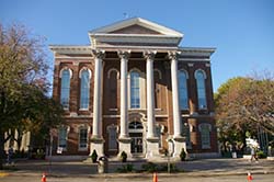
Warren County Courthouse, Bowling Green, KY.
In 1798 settlers laid out a town on land donated by Robert and George Moore. That town, named Bowling Green, became the county seat by legislative proclamation in 1809 after several competing settlements sought the honor.
Bowling Green grew steadily during the early nineteenth century as a commercial center for the surrounding agricultural region. The town was formally incorporated in 1812. See postcards of Bowling Green.
Rivers, Land, and Natural Features
The Green River defines Warren County’s northern boundary and provided an important transportation route for early settlers. Within the county, major waterways include the Barren and Gasper rivers, as well as Drake’s and Jennings creeks and Bay’s Fork.
Terrain varies across the region. The northern area between the Green and Barren rivers is rugged, with notable ridges near Riverside and Richardsville. The Barren River cuts through Bowling Green, where several hills later became sites for forts and public facilities. Rolling land occurs in the east near Drake’s Creek, while the south and southwest are predominantly flat. Western Warren County is hillier and more rocky, especially near the Gasper River, and Shanty Hollow Lake lies in the northwest.

Map of Warren County. Source: WKU.EDU
Agriculture and Land Use
Fertile flatlands in the west and the south support tobacco, hay, corn, and soybean production. Other areas feature clay and rocky soils less suited to crop farming; these have historically supported livestock, horses, and hunting.
Transportation and Economic Development
Riverboat trade helped Warren County thrive in the agricultural market. In 1859 the Louisville and Nashville Railroad was constructed through the county, expanding access to regional trade.
Civil War and Its Impact
During the Civil War, Bowling Green’s strategic location made it important to both sides. Confederate forces occupied the area in September 1861, and it was retaken by Union troops on February 14, 1862. In their withdrawal, Confederate troops damaged railroad bridges and facilities to slow Union pursuit.
Reconstruction to Twentieth Century Growth
After the war, agriculture and transportation continued to shape county life. Bowling Green grew as a commercial center in the late nineteenth century as rail connections strengthened regional networks.
Modern Development
The completion of Interstate 65 and the Green River Parkway in the 1960s and 1970s sparked industrial growth, shifting Warren County’s economy from chiefly rural to more urban and diversified.