Repositories & Records
The Boyle County Courthouse in Danville houses deeds, marriage records, probate files, and circuit and
district court orders from the county’s formation forward. The
Boyle County Clerk’s Office
provides access to recorded land and marriage records, while the
Office of the Circuit Court
Clerk
oversees court case files. Many older volumes have been microfilmed and can be accessed through the
Kentucky Department for Libraries and Archives (KDLA).
The Boyle County Public Library in Danville maintains a strong
local history and genealogy collection, including family files, local and regional histories, cemetery
readings, and historic newspapers. Its Kentucky Room and digital projects support research on Boyle County
as well as the earlier Lincoln and Mercer County records that cover the “pre-Boyle” era.
Notes
Notable Places:
Key communities in Boyle County include Danville (county seat), Perryville, Junction City, Parksville,
Mitchellsburg, Alum Springs, and Forkland. Constitution Square in Danville preserves the site where
Kentucky’s early constitutional conventions met, while nearby Centre College and the Kentucky School for
the Deaf have generated rich institutional records. The Perryville Battlefield, just west of Danville,
marks one of the largest Civil War engagements fought in Kentucky.
Research Notes:
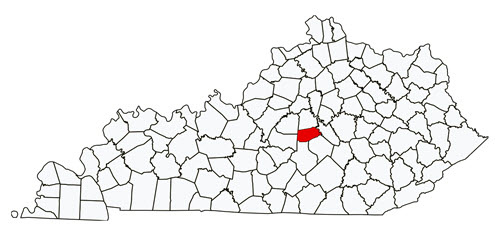
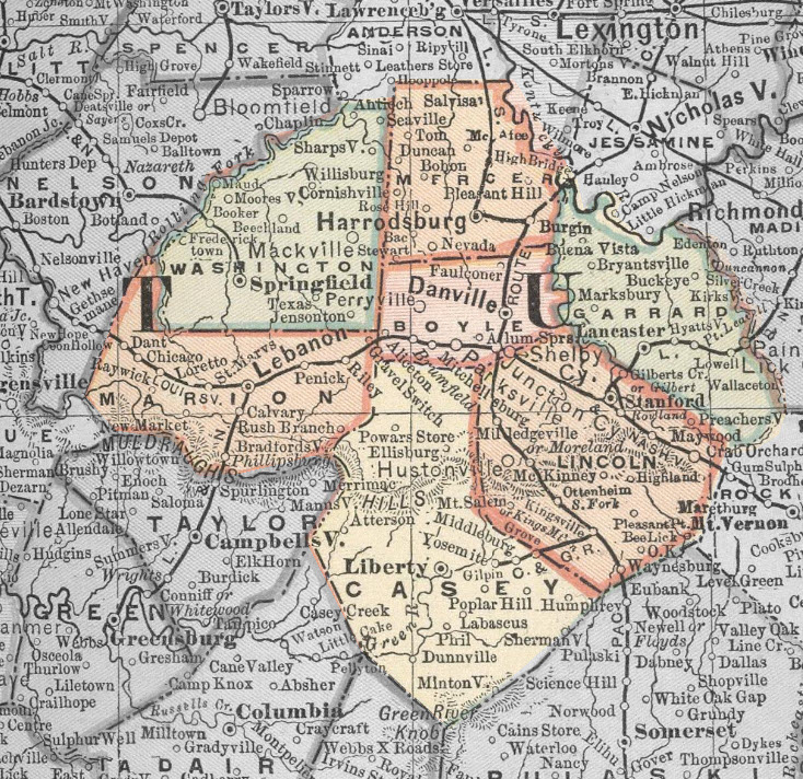
Because Boyle County was formed in 1842, earlier land and tax records for residents in this area will be
found in Mercer and Lincoln County series. The 1860 courthouse fire created gaps among the earliest Boyle
County volumes, so it is worth checking overlapping records in neighboring counties, private papers, and
church minutes. For the Civil War period, materials relating to the Battle of Perryville, veterans’ records,
and local newspaper coverage can help reconstruct families who were displaced, wounded, or killed during the
conflict. The presence of multiple schools and colleges in Danville also means that yearbooks, student
rosters, and institutional histories may provide unexpected genealogical details.
Centre College Archives in Danville is another key repository for Boyle County research.
The archives preserve faculty and student records, campus publications, historical photographs,
diaries, maps, and manuscript collections connected to Danville families and civic life.
Because Centre has been a major educational institution since 1819, its holdings often include
materials from the “pre-Boyle” period and can help document residents who appear only briefly
in county records.
Migration Patterns:
Boyle County lies along routes once tied to the old Wilderness Road and later highways U.S. 150 and U.S. 127.
Many early settlers came from Virginia and the Upper South, filtering through Lincoln and Mercer Counties
before Boyle County was formed. In the late 1800s and early 1900s, families moved in and out of the area
with changes in farming, rail connections, and employment in Danville’s businesses and schools. There is
frequent movement between Boyle and its neighbors—especially Lincoln, Mercer, and Casey Counties—so
researchers should be prepared to follow families across county lines over several decades.
Map is from the 1891 Appleton Map of Kentucky.
Found in the David Rumsey Map Collection.