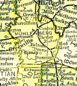
Muhlenberg County Kentucky
Cemeteries F
Fortney Cemetery
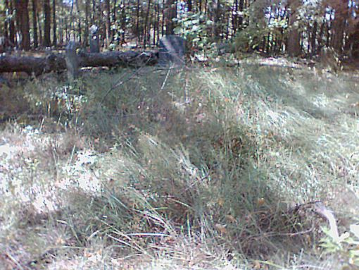
Fortney Cemetery before being cleared by Jerry Mohnen & Tom Bolton.
Burials
- Arnold, C.W. Born 5 Jan 1864. Died 18 Jan 1916.
- Ball, Henry C. Born 12 Mar 1834. Died 11 Feb 1906.
- Doss, Azariah. Died 23 Sept 1848, age 56 years, 9 months, 28 days.
- Drake, David E.F. Born 6 June 1843. Died 3 Feb 1927.
- Drake, Rudolph K. Born 13 Oct 1881. Died 5 Sept 1903. Son of D.E.F. & S.F. Drake.
- Drake, Sarah F. Born 16 Oct 1849. Died 27 Dec 1930.
- Fortney, A.J. Born 12 Jan 1826. Died 1873.
- Fortney, Alice. Born 1875. Died 1954.
- Fortney, Anna Doris. Born 6 Dec 1926. Died 4 Apr 1928.
- Fortney, Carmen L. Born 13 Nov 1908. Died 25 Aug 1909. Daughter of A.L. & M.C. Fortney.
- Fortney, Cynthia H. Born 19 June 1808. Died 12 Mar 1891.
- Fortney, Eli B. Born 14 Oct 1804. Died 13 Sept 1892.
- Fortney, Fallie Belle. Born 18 Mar 1877. Died 30 Aug 1923.
- Fortney, J.G.W. Born 19 June 1840. Died 12 June 1912.
- Fortney, James J. Born 1875. Died 1929.
- Fortney, Joseph L. Born 23 Aug 1878. Died 25 Feb 1879.
- Fortney, Henderson Wayne. Born 9 June 1865. Died 17 May 1945.
- Fortney, Louella. Born 29 June 1883. Died 4 Nov 1955.
- Fortney, Mable. Born 11 Oct 1901. Died 26 July 1903.
- Fortney, Nancy. Born 28 Aug 1799. Died 3 July 1875.
- Fortney, Sarah A. Born 17 June 1842. Died 18 June 1908.
- Fortney, Susan. Born 1845. Died 1928.
- Fortney, W.H. Born 30 Aug 1833. Died 16 Apr 1924.
- Fortney, Wanda Jean. Born 23 Aug 1929. Died 12 Oct 1929.
- Fortney, William Eric. Born 16 Aug 1931. Died 22 May 1933.
- Jones, Buck. Born 16 Apr 1873. Died 2 Mar 1927.
- Jones, Palina Z. Born 22 May 1875. Died 17 Feb 1937.
- Lacefield, Annie F. Born 8 Aug 1871. Died 9 Nov 1919. Wife of W.E. Lacefield.
- Lacefield, Nagle. Born 27 July 1904. Died 14 Jan 1925.
- Lacefield, W.E. Born 23 Aug 1870. Died 17 Mar 1933. Husband of Annie F. Lacefield.
- Lacefield, William G. Born 31 Mar 1920. Died 30 May 1975. PFC US Army World War II.
- Lacefield, William O. Born 21 May 1892. Died 23 Apr 1967.
- Morris, Sarah M. Born 27 Nov 1875. Died 21 May 1900. Daughter of W.H. & S.A. Fortney. Wife of H.A. Morris.
- Whitmer, Annie A. Born 8 Jan 1888. Died 19 Aug 1965.
- Whitmer, George R. Born 21 July 1879. Died 7 Apr 1932.
- Whitmer, Leroy. Born 21 Feb 1909. Died 21 Feb 1909. Son of A. & G. Whitmer.
- Whitmer, Marshel R. Born 11 Sept 1905. Died 25 June 1906. Son of G.R. & A.A. Whitmer.
- Wilcox, Margaret L. Born 22 Dec 1840. Died 19 Sept 1905. Wife of J.I. Wilcox.
Contributed by Jerry Mohnen & Tom Bolton
Location
Fortney Cemetery is in the middle of strip mining south of Central City.
According to Kentucky Department of Transportation Local Roads map, Kentucky Route 1081 (Stringtown Road) should take you to both Stewart Cemetery and Fortney Cemetery. But the easiest access to the cemeteries may be the mine entrance off US Route 62 West about ½ mile west of Walmart Supercenter.
Enter the coordinates in your GPS and use your best judgment.
GPS coordinates: 37.264053, -87.118823.
Updated December 24, 2025.